Solar radiation takes a long journey until it reaches Earth’s surface. So when modelling solar radiation, various interactions of extra-terrestrial solar radiation with the Earth’s atmosphere, surface and objects are to be taken into account.
State-of-art solar irradiance models as Solargis make use of the most modern input data (satellite and atmospheric), which are systematically quality-controlled and validated. Models and input data are integrated and regionally adapted to perform reliably at a wide range of geographical conditions.
This process is based on sound theoretical grounds and shows consistent and computationally stable results. Old approaches are typically less elaborated, thus cannot reach the accuracy of the modern models. Even if the models are based on similar principles, differences in implementation may result in different outputs.
Satellite-based irradiance models are able to estimate the solar radiation levels (historic, recent and future levels) without the need of installing ground sensors at the location of interest. Satellite-based irradiance models range from physically rigorous to purely empirical:
For historical and recent data, Solargis uses a semi-empirical solar radiation model. Data from satellites are used for identification of cloud properties using the most advance algorithms. Most of the physical processes of atmospheric attenuation of solar radiation are considered and some physical parameters on the input are also used. Therefore, this approach is capable to reproduce real situations.
On the other hand, outputs from operational numerical weather models (NWP) are used for forecast data; in the post-processing phase, operationally calculated information from the satellite model is used for dynamic improvement of the accuracy of the forecast.
The solar radiation retrieval in Solargis satellite-to-irradiance model is basically split into three steps:

Solargis methodology scheme
The most advanced input data are used in the Solargis algorithms. As a result, satellite-data secure very high temporal coverage (more than 99% in most of regions). The supplied time-series data have all the gaps filled using intelligent algorithms.
Primary time step of solar resource parameters is 15 minutes for MSG satellite area, 30-minutes for MFG and MTSAT satellite area, and 30-minutes (and partially up to 3 hourly) for GOES satellite area. Atmospheric parameters (aerosols and water vapour) represent daily data.
Spatial resolution of Meteosat, GOES, and MTSAT data considered in the calculation scheme is approximately 3 km at sub-satellite point (more details in the table below). Model outputs are resampled to 2 arc-minutes (app. 4x4 km) regular grid in WGS84 geographical coordinate system.
The spatial resolution of data products is enhanced up to 3 arc-seconds (which is about 90 meters at the equator, less towards the poles).
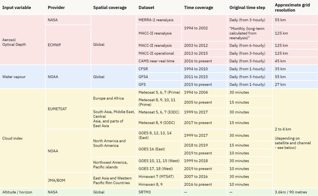
Input data used in the Solargis model
Approximate pixel size for different regions covered by satellites for the cloud index calculation


