Produkty
menu item
Prospect
Odhadnite solárny potenciál vašej lokality
menu item
Evaluate
Time Series a TMY dáta pre optimálny dizajn elektrárne
menu item
Monitor
Hodnotenie fotovoltického výstupu v reálnom čase
menu item
Forecast
Predpoveď výroby solárnej energie na až 14 dní
menu item
Analyst
Spravujte všetky solárne dáta na jednom mieste
menu item
Integrácie
Automatizujte dodávku Solargis dát
Príklady použitia
menu item
Výber lokality
Nájdite správnu lokalitu pre váš solárny projekt
menu item
Simulácia energetického výnosu
Analyzujte potenciálne zisky a riziká
menu item
Optimalizácia návrhu elektrárne
Nájdite optimálny dizajn pre vašu solárnu elektráreň
menu item
Skutočný výkon elektrárne
Poznajte skutočný výnos vašej elektrárne
menu item
Predpoveď výkonu
Predpovedajte výnos z vášho solárneho projektu
menu item
Overenie pozemných dát
Overte si kvalitu solárnych a meteo meraní
Hodnotenie solárneho zdroja a meteorologických dát
Detailné hodnotenie a validácia solárneho zdroja
Prispôsobenie modelov Solargis lokalite
Kombinácia satelitných dát s lokálnymi meraniami
Kontrola kvality solárnych a meteorologických meraní
Oprava chýb v dátach z pozemných meraní
GIS dáta na mieru
Solargis GIS dáta prispôsobené pre vaše aplikácie
Posúdenie energetického výnosu z fotovoltiky
Odhadnite neistotu vstupných dát
Hodnotenie výkonu fotovoltiky
Odhad energie pre refinancovanie alebo akvizíciu
Štúdia PV variability a optimalizácie skladovania energie
Pochopte variabilitu výstupu naprieč regiónmi
Regionálna štúdia potenciálu solárnej energie
Identifikácia lokalít pre solárne elektrárne
Naša expertíza
Ako naša technológia funguje?
Metodológia
Ako preklápame vedu do technológie?
API & integrácia
Ako integrovať Solargis dáta cez API
Príručky a dokumentácia
Release notes
Príbehy klientov
Blog
Ebooky
Webináre
Publikácie
Udalosti
Bezplatné mapy a GIS dáta
Mapy solárneho výkonu
O spoločnosti Solargis
Partneri
ISO certifikáty
Kariéra

Táto stránka zatiaľ nie je preložená do slovenčiny. Pozrieť si ju môžete v angličtine.

Solar radiation takes a long journey until it reaches Earth’s surface. So when modelling solar radiation, various interactions of extra-terrestrial solar radiation with the Earth’s atmosphere, surface and objects are to be taken into account.

Overview

State-of-art solar irradiance models as Solargis make use of the most modern input data (satellite and atmospheric), which are systematically quality-controlled and validated. Models and input data are integrated and regionally adapted to perform reliably at a wide range of geographical conditions.

This process is based on sound theoretical grounds and shows consistent and computationally stable results. Old approaches are typically less elaborated, thus cannot reach the accuracy of the modern models. Even if the models are based on similar principles, differences in implementation may result in different outputs.

Satellite-based irradiance models are able to estimate the solar radiation levels (historic, recent and future levels) without the need of installing ground sensors at the location of interest. Satellite-based irradiance models range from physically rigorous to purely empirical:

  • Physical models attempt to explain observed earth’s radiance by solving radiative-transfer equations. These models require precise information on the composition of the atmosphere and also depend on accurate calibration from the satellite sensors.
  • Empirical models consist of a simple regression between the satellite visible channel’s recorded intensity and a measuring station at the earth’s surface.
  • Semi-empirical models use a simple radiative-transfer approach and some degree of fitting to observations. Today, all operational approaches are based on the use of this.

Solargis algorithms

For historical and recent data, Solargis uses a semi-empirical solar radiation model. Data from satellites are used for identification of cloud properties using the most advance algorithms. Most of the physical processes of atmospheric attenuation of solar radiation are considered and some physical parameters on the input are also used. Therefore, this approach is capable to reproduce real situations.

On the other hand, outputs from operational numerical weather models (NWP) are used for forecast data; in the post-processing phase, operationally calculated information from the satellite model is used for dynamic improvement of the accuracy of the forecast.

The solar radiation retrieval in Solargis satellite-to-irradiance model is basically split into three steps:

  • First, the clear-sky irradiance (the irradiance reaching ground with assumption of absence of clouds) is calculated using the clear-sky model.
  • Second, the satellite data (information from several geostationary satellites) used to quantify the attenuation effect of clouds by means of cloud index calculation. The clear-sky irradiance is coupled with cloud index to retrieve all-sky irradiance. The outcome of the procedure is direct normal and global horizontal irradiance.
  • Third, direct normal and global horizontal irradiance are used for computing diffuse and global tilted irradiance (irradiance in plane of array, on tilted or tracking surfaces) and/or irradiance corrected for shading effects from surrounding terrain or objects.


SG Methodology scheme sand

Solargis methodology scheme


Solargis inputs description

The most advanced input data are used in the Solargis algorithms. As a result, satellite-data secure very high temporal coverage (more than 99% in most of regions). The supplied time-series data have all the gaps filled using intelligent algorithms.

Primary time step of solar resource parameters is 15 minutes for MSG satellite area, 30-minutes for MFG and MTSAT satellite area, and 30-minutes (and partially up to 3 hourly) for GOES satellite area. Atmospheric parameters (aerosols and water vapour) represent daily data.

Spatial resolution of Meteosat, GOES, and MTSAT data considered in the calculation scheme is approximately 3 km at sub-satellite point (more details in the table below). Model outputs are resampled to 2 arc-minutes (app. 4x4 km) regular grid in WGS84 geographical coordinate system.

The spatial resolution of data products is enhanced up to 3 arc-seconds (which is about 90 meters at the equator, less towards the poles).
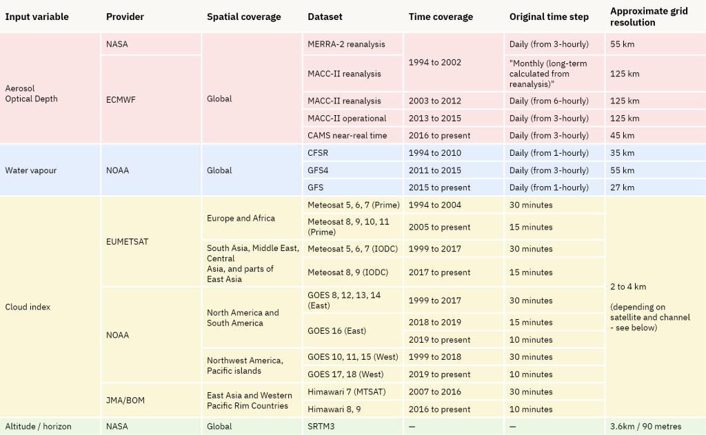
 

Input data used in the Solargis model

Input data used in the Solargis model


Approximate pixel size for different regions covered by satellites for the cloud index calculation

Approximate pixel size for different regions covered by satellites for the cloud index calculation

Frequently Asked Questions#