Produkty
menu item
Prospect
Odhadnite solárny potenciál vašej lokality
menu item
Evaluate
Time Series a TMY dáta pre optimálny dizajn elektrárne
menu item
Monitor
Hodnotenie fotovoltického výstupu v reálnom čase
menu item
Forecast
Predpoveď výroby solárnej energie na až 14 dní
menu item
Analyst
Spravujte všetky solárne dáta na jednom mieste
menu item
Integrácie
Automatizujte dodávku Solargis dát
Príklady použitia
menu item
Výber lokality
Nájdite správnu lokalitu pre váš solárny projekt
menu item
Simulácia energetického výnosu
Analyzujte potenciálne zisky a riziká
menu item
Optimalizácia návrhu elektrárne
Nájdite optimálny dizajn pre vašu solárnu elektráreň
menu item
Skutočný výkon elektrárne
Poznajte skutočný výnos vašej elektrárne
menu item
Predpoveď výkonu
Predpovedajte výnos z vášho solárneho projektu
menu item
Overenie pozemných dát
Overte si kvalitu solárnych a meteo meraní
Hodnotenie solárneho zdroja a meteorologických dát
Detailné hodnotenie a validácia solárneho zdroja
Prispôsobenie modelov Solargis lokalite
Kombinácia satelitných dát s lokálnymi meraniami
Kontrola kvality solárnych a meteorologických meraní
Oprava chýb v dátach z pozemných meraní
GIS dáta na mieru
Solargis GIS dáta prispôsobené pre vaše aplikácie
Posúdenie energetického výnosu z fotovoltiky
Odhadnite neistotu vstupných dát
Hodnotenie výkonu fotovoltiky
Odhad energie pre refinancovanie alebo akvizíciu
Štúdia PV variability a optimalizácie skladovania energie
Pochopte variabilitu výstupu naprieč regiónmi
Regionálna štúdia potenciálu solárnej energie
Identifikácia lokalít pre solárne elektrárne
menu item
Prospect
Odhadnite solárny potenciál vašej lokality
menu item
Evaluate
Time Series a TMY dáta pre optimálny dizajn elektrárne
menu item
Monitor
Hodnotenie fotovoltického výstupu v reálnom čase
menu item
Forecast
Predpoveď výroby solárnej energie na až 14 dní
Naša expertíza
Ako naša technológia funguje?
Metodológia
Ako preklápame vedu do technológie?
Knowledge base
Release notes
Príbehy klientov
Blog
Ebooky
Webináre
Publikácie
Udalosti
Bezplatné mapy a GIS dáta
O spoločnosti Solargis
Partneri
ISO certifikáty
Kariéra

Táto stránka zatiaľ nie je preložená do slovenčiny. Pozrieť si ju môžete v angličtine.

New generation Solargis Evaluate: data, PV design & simulation, analysis, and reports in one cloud-based solution. Discover more ->

We’ve just added another layer of precision to Solargis Evaluate. Following the recent launch of snow loss calculations, soiling losses are now also part of our PV simulation toolkit – helping developers, investors, and technical advisors model real-world PV performance more accurately.

The new Solargis Evaluate, launched earlier this year, now allows users to automatically simulate soiling losses using the Solargis soiling loss model. This helps PV developers and operators plan solar panel maintenance more effectively and mitigate financial losses caused by soiling.

Why calculating soiling losses matters?

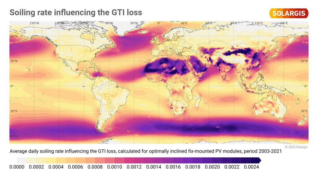
Soiling occurs when dust, sand, pollen, pollution, or other particles accumulate on PV modules, reducing the amount of solar radiation that reaches the cells and thereby lowering energy production. In some regions, soiling can cause substantial energy losses if not properly monitored and managed.

Understanding soiling losses is critical especially in arid and semi-arid locations, but also in areas with high agricultural or industrial activity. As these losses directly impact PV output, accounting for them is key to realistic performance estimates and better-informed decisions.

Soiling rate (1)

How does Solargis Evaluate calculate soiling losses?

The Solargis soiling model consists of two main components:

  • Accumulation of particles – The model calculates the mass (m) of suspended particles deposited on PV surfaces, considering both natural and scheduled cleaning events.
  • Soling ratio calculation – Once the accumulated mass (m) is determined, an empirical relationship estimates the soiling ratio.

The Solargis soiling model integrates data from two leading sources:

  • Meteorological parameters including temperature, atmospheric pressure, wind speed, and rainfall are sourced from ERA5 (31 km resolution) and ERA5-Land (9 km resolution).
  • Particulate matter parameters (PM2.5 and PM10) are derived through harmonized data from multiple sources, based on CAMS reanalysis (80 km resolution, 3-hour intervals). This coarser resolution may reduce local accuracy.

When calculating soiling losses, Solargis Evaluate users can now choose from three options:

  • Soiling loss simulation calculated by the Solargis soiling loss model
  • Option to manually configure monthly soiling loss values if you have your own assumptions based on site knowledge, cleaning schedules, or available field data
  • Default setting – flat soiling losses value (3%)

Soiling losses

soiling graph 3

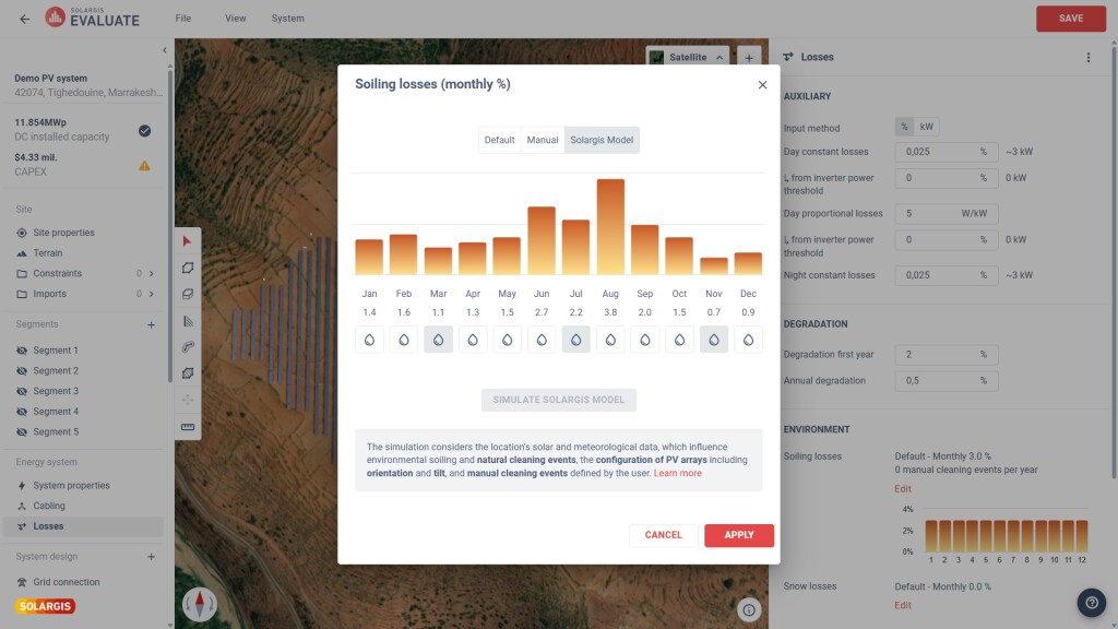
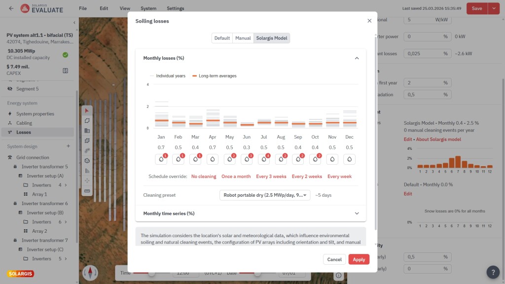
Once defined, the losses are factored directly into the energy yield calculations, providing a more accurate PVOUT (net AC output) and giving you a better understanding of how soiling affects your project’s performance over time.

This functionality is available in the Energy System Designer within Solargis Evaluate, where soiling losses can be applied on a monthly basis.

Why soiling losses matter for bankability

Incorporating soiling losses into energy yield simulations ensures that financial models reflect the true variability of PV performance. It helps you:

  • Avoid overestimation of annual energy yield
  • Better reflect cleaning strategy and maintenance planning
  • Improve accuracy in energy assessments submitted for due diligence

As with snow losses, our aim is to equip you with solutions that reflect the realities of PV operations in different environments and climatic zones.

Solargis Evaluate offers the most precise PV simulation on the market

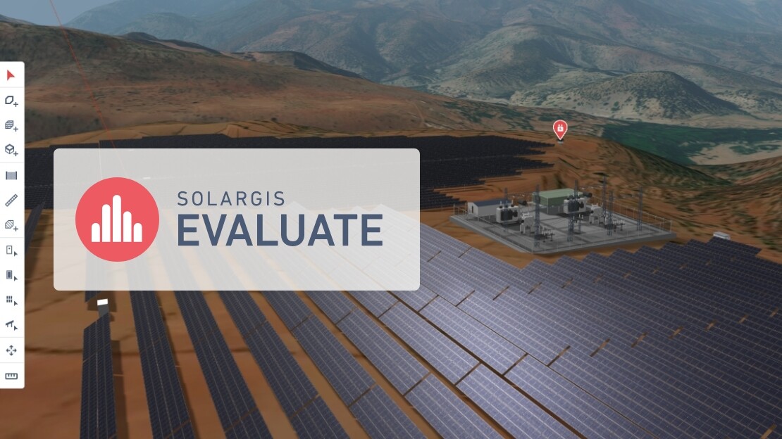
Solargis Evaluate is designed to bring a new level of precision to PV project evaluation. Leveraging 15-minute time series data, proprietary albedo data, ray tracing technology for bifacial PV simulations, and now snow and soiling loss modeling, you can capture more variables that affect PV performance – all in one cloud-based platform.

Want to learn more about how to apply soiling loss assumptions in your project?

Learn more about the Solargis soiling loss model here.

Keep reading

Introducing Solargis Evaluate 2.0: A new standard for PV project design and evaluation
Solargis news

Introducing Solargis Evaluate 2.0: A new standard for PV project design and evaluation

Today, we launched Solargis Evaluate 2.0, the next generation of our Evaluate solution. The new Evaluate is a more advanced, cloud-based platform for complete PV project design and evaluation, equipping project developers and industry experts with all the tools needed to tackle the growing complexity of modern solar projects.

Product news: New map layers in Solargis Prospect for smarter PV decisions
Solargis news

Product news: New map layers in Solargis Prospect for smarter PV decisions

We’re introducing eight new map layers in Solargis Prospect, designed to provide quick insights into factors affecting the performance, durability, and risk profile of photovoltaic (PV) systems. These new layers offer essential data for PV project engineers, developers, and financial planners, helping them make informed decisions about site selection, system design, and long-term investment strategies.

Product news: Snow losses calculation now available in Solargis Evaluate
Solargis news

Product news: Snow losses calculation now available in Solargis Evaluate

Solargis Evaluate now includes snow loss calculations, providing developers with a more realistic estimate of energy production in regions affected by snowfall. This is one of the latest enhancements in the new Solargis Evaluate platform, launched in early 2025.