Ground data verification
Identify sensor, soiling, shading, and equipment issues by improving data quality. Harmonize inputs from multiple sources and fill in the gaps.
![[Increase quality of measurements] for regular performance reporting](https://files.solargis.com/public/Blocks/solution-ground-data-verification-banner__FitWzE1OTUsNzIwXQ.jpg)

The accuracy of on-site pyranometer readings can be affected by a number of different factors. Therefore, it is vital to have reliable reference data to understand how correct your measurements are.
Thanks to data analysis supported by our satellite-based Time Series, Solargis is able to identify and flag errors in measured data and recommend improvements to reduce the occurrence of these issues.
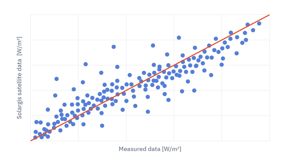
The output of models may not always perfectly reflect local conditions.
Measured data combined with time series help improve our models and provide you with more precise inputs.
By complementing satellite irradiation data with ground measurements, you can reduce the uncertainty of energy output estimates.
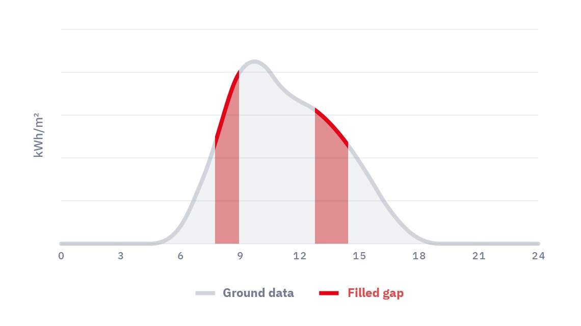
Measurements from operational power plants often come from multiple sensors.
We take these measurements, run quality controls, harmonize, and gap-fill data to assemble a complete time series that is ready for regular performance evaluation.
We help you convert your on-site measurements into bankable reports trusted by financial stakeholders all around the world.
One of the key challenges of measured solar irradiance data is the high occurrence of anomalous values.
The Quality Control of Solar & Meteo Measurements service, based on our experience with measurements from hundreds of locations globally, helps you identify errors and prepare the datasets for the next steps of your project.
Combine satellite data with on-site measurements to reduce the uncertainty of estimated energy output and achieve more accurate financial estimates.
The Site Adaptation of Solargis Models service will give you locally enhanced solar and meteo parameters, enabling you to reduce uncertainty of power plant design and energy yield simulations.
Since there is effectively no updated independent study that compares all databases globally, validation statistics are one of the most important tools when comparing models from different providers.
In this webinar we cover how to evaluate the impact of the different factors that can affect the accuracy of your ground-measured data.
Designing and operating a large-scale solar project without fully understanding its potential output inevitably increases risks throughout its lifecycle. One part of the solution for developers is validated solar resource data calculated through satellite-based models, helping produce accurate energy yield calculations.
Projects supported by our bankable solar & meteo data, software, and services every year
Years of experience with solar projects and improving industry standards
Coverage of the world’s population with 30 years of solar and meteorological data


