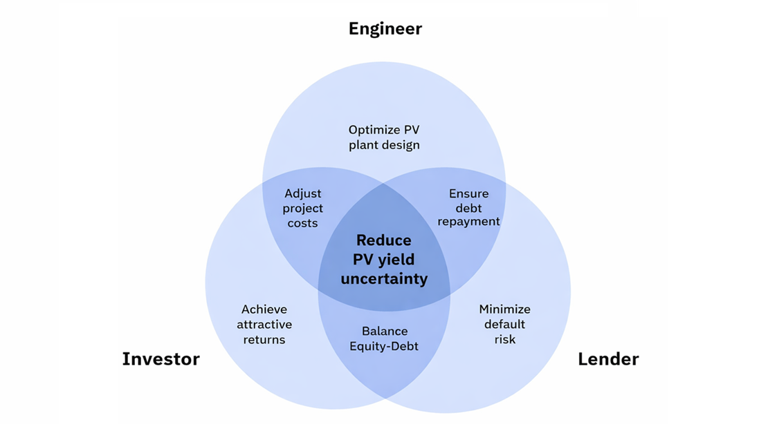
Join our upcoming webinar "Can you rely on measured data?" on October 27, 2026 at 10:00 AM CET. Register here

Martin Opatovský
May 27, 2026
Depending on location and conditions, satellite-based solar resource data typically have uncertainty in the range of about 4–8%.
With high-quality ground measurements and proper site adaptation, that uncertainty can often be reduced to around 3–5%.
This reduction may look small but it is commercially meaningful for many utility-scale PV projects.
[Want to learn how reducing uncertainty through site adaptation can open the door to better design decisions and more favorable financing? Watch our webinar "How site adaptation reduces your energy yield uncertainty"]
Every utility-scale solar project is built around a simple but critical question: how much energy will this PV plant produce?
The answer depends heavily on the solar resource at the location of the PV power plant. Expected annual energy yield affects plant design, production targets, power purchase agreements, financial models, debt sizing, and investor return expectations.
But behind the expected yield number there is always a range of uncertainty.
Financing institutions typically focus on conservative production scenarios, such as P90 yield, which are directly influenced by the uncertainty of solar resource data. Lower uncertainty means a higher P90 value, and a higher P90 value can improve the project’s bankability.
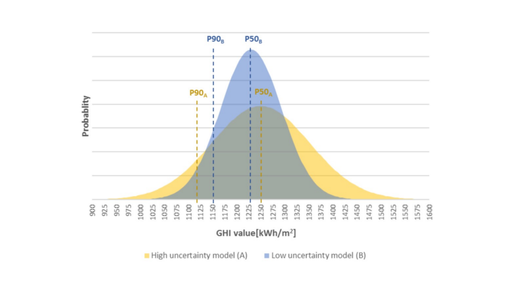
At the same time, production targets and purchase agreements are usually built around the P50, or expected solar resource. To set up a power purchase agreement that a project can actually deliver, developers need an accurate assessment of the solar resource at the site.
This creates two important objectives:
Site adaptation helps address both.
A reduction of solar resource uncertainty by roughly 1–3 percentage points can lift the P90 yield by 2-3 percentage points. On a 100 MWp project, this will translate to approximately $1–2M additional debt capacity with no change to the physical asset.
The power plant is the same. The technology is the same. What changes is the confidence in the expected and conservative production values.
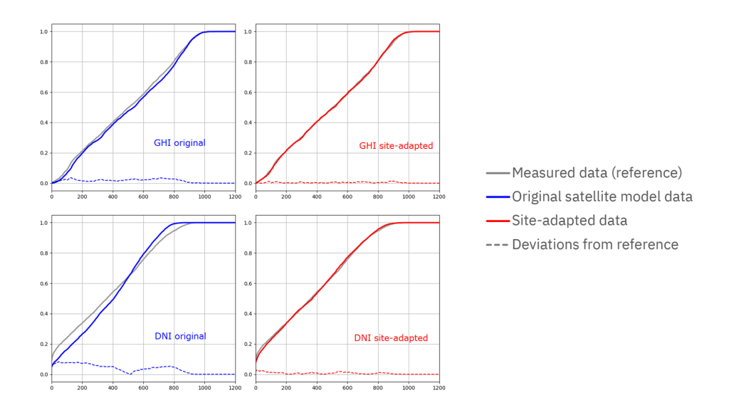
Site adaptation also helps correct systematic bias in satellite-based datasets. Local microclimate, terrain, aerosols, cloud patterns, or site-specific conditions may not be fully captured by the model alone. Ground measurements provide a local reference point that can be used to adjust the satellite-based data.
This is important because gaps between pre-construction expectations and operational reality can be significant. Differences of 5–10% between production targets and actual performance are not uncommon, and inflated or poorly validated solar resource assessments can be one contributing factor.
This becomes critical in markets with increasing solar penetration. As more PV generation enters the system, intraday price patterns change, making it important to understand not only how much energy a project will produce, but also when it will produce it.
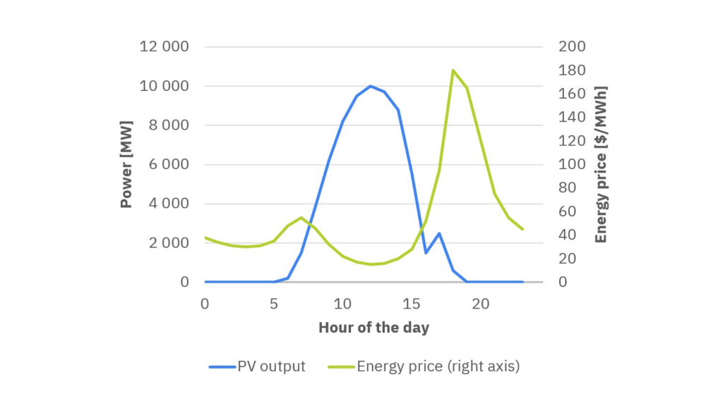
An accurate baseline supports better PV power plant design, including decisions around DC/AC ratio, hybridization with battery storage, clipping strategy, and operational expectations. It also helps protect PPA obligations, asset valuations, and long-term stakeholder trust.
Site adaptation combines the strengths of two data sources: satellite-based solar resource models and ground-based measurements.
Satellite data provides long-term, spatially consistent coverage. It can extend across decades and allows developers to understand long-term variability.
Ground measurements provide local accuracy. They capture site-specific conditions directly, including local atmospheric patterns and microclimate effects that may be difficult to fully represent through satellite modelling alone.
However, ground measurements are usually short-term. They may cover one or two years, and they often contain gaps or errors. Instruments can suffer from soiling, shading, misalignment, calibration drift, interruptions, or maintenance issues.
Site adaptation uses quality-controlled ground measurements as a reference and aligns the satellite-based model with the real conditions observed at the site.
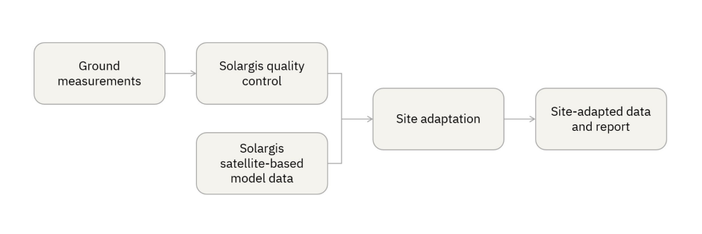
The result is a long-term, gap-free, site-adapted dataset that reflects both local measurements and long-term climate variability. Read more about how site adaptation works.
Ground measurements are central to site adaptation. But they only help if they are accurate enough to improve the satellite-based data rather than add noise.
A well-installed and properly maintained Class A pyranometer can achieve measurement uncertainty of around 3%. This makes it a strong reference for improving the uncertainty of the solar resource assessment.
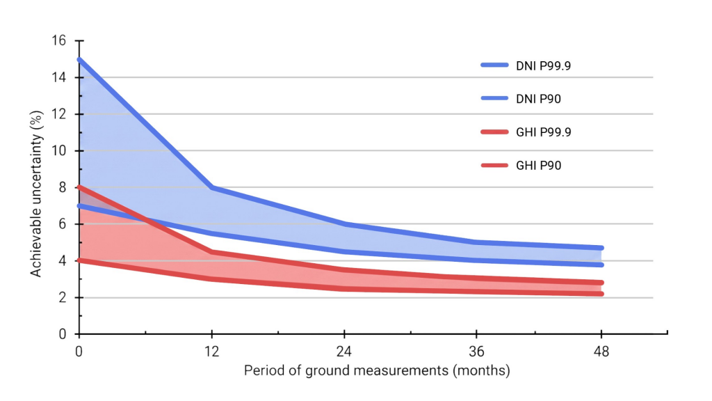
But measurement quality depends on more than the sensor class. Installation, cleaning, calibration, horizon conditions, shading, levelling, maintenance, and data acquisition all matter. Poorly installed or poorly maintained measurement equipment can introduce errors that weaken the assessment. Instead of reducing uncertainty, bad measurements can increase it.
That is why measurement campaigns should be planned carefully from the start. For site adaptation, Solargis typically recommends at least 12 months of ground measurements with 1- to 10-minute temporal resolution, including solar radiation and relevant meteorological parameters.
The more reliable the measurement campaign, the stronger the foundation for site adaptation.
Even the best sensors can produce bad data.
A pyranometer may be temporarily shaded. A sensor may become soiled. A tracker-mounted measurement may be misaligned. A data logger may fail. Cleaning or maintenance events may create artificial jumps. Extreme conditions may expose inconsistencies that are not visible in ordinary periods.
This is why quality control is a must.
Before measurements can be used for site adaptation, they need to be checked, flagged, and filtered. In practice, a meaningful share of measurement records may be excluded through quality control. It is not unusual for around 10% of raw measurements to be flagged or removed, depending on the quality of the campaign and local conditions.
Robust quality control requires a multi-level methodology. It should identify physical inconsistencies, sensor problems, outliers, gaps, unrealistic patterns, and mismatches between measured parameters. It should also consider the relationship between GHI, DNI, diffuse radiation, sun position, and meteorological conditions.
The goal is to make sure that only reliable measurements are used as the reference for adapting the satellite model.
At its simplest, site adaptation may sound like a statistical correction: compare satellite data with ground measurements, calculate the bias, and adjust the model.
In practice, good site adaptation is much more sophisticated.
Basic statistical methods can reduce bias, but they may fail to preserve the physical consistency of the dataset. For example, correcting GHI without properly considering DNI and diffuse irradiance can create inconsistency between the three irradiance components.
Adjusting short-term data without understanding seasonal patterns can lead to overcorrection. Treating extreme events incorrectly can distort the long-term distribution.
This is why site adaptation requires solar resource know-how, not just data processing.
The choice of method depends on the reference measurements, site conditions, climate, terrain, available parameters, and the behaviour of the satellite model in that region. Multiple methods may need to be combined to respect seasonal and daily patterns.
Advanced site adaptation should preserve the physical behavior of the solar resource, not only reduce a statistical error metric. This requires deep control of the underlying solar model, something that distinguishes providers who operate their own models from those relying mainly on external datasets and statistical correction.
Without the right know-how, poorly executed site adaptation can create a new set of problems.
Common risks include:
This is why a robust site adaptation process needs both high-quality measurements and deep understanding of solar resource physics.
Solargis provides a tailored Site Adaptation service that helps project teams transform their ground measurements into decision-grade solar resource data. The process requires customer-provided ground measurements covering at least 12 months of data at 1- to 10-minute temporal resolution, including solar radiation and key meteorological parameters.
Solargis also collects structured information about the measurement station, including equipment, installation, calibration, maintenance, and local conditions. This helps assess whether the measurements are suitable for site adaptation and how they should be used.
Once we obtain the data and process them, Solargis provides:
In Solargis Evaluate, you can now order the Site Adaptation service in just five clicks, giving your development and technical teams access to improved data for yield simulations and project evaluation, along with an invaluable competitive advantage.
A great example of site adaptation comes from Solargis’ collaboration with Convergent Energy + Power and GroundWork Renewables in Puerto Rico.
The client needed highly accurate, site-specific resource data to design solar-plus-storage systems with confidence and to secure financing. Solargis integrated approximately a year’s worth of ground-based GHI and meteorological measurements with long-term data from satellite-based solar models.
GroundWork carried out the on-site monitoring campaign, ensuring instrument calibration, maintenance, and rigorous quality control. Using these high-frequency measurements, Solargis generated high-resolution synthetic data at one-minute intervals by correlating ground and satellite observations.
The adapted dataset:
This dataset became the basis for optimizing PV plant design, including DC/AC ratio and storage configuration. Reliable solar resource data was especially critical to model ramp-rate control, where batteries must mitigate rapid fluctuations in irradiance to ensure stable grid integration.
By combining ground truth with satellite coverage, site adaptation delivered the high-quality, bankable dataset Convergent needed — reducing uncertainty and increasing stakeholder confidence. Read the full case study here.
The best time to think about site adaptation is before the measurement campaign begins.
If a project team starts measuring early, and if the measurement station is properly designed, installed, maintained, and documented, those measurements can later be used to improve the solar resource dataset.
In practical terms: if you are developing a utility-scale PV project, measure, and measure properly.
With good measurements, Solargis can assess the quality of the monitoring station, perform quality control, harmonize the measured data, and use the results to generate improved site-adapted datasets in Solargis Evaluate.
After one year of reliable measurements, your project can benefit from more accurate data, better simulations, higher confidence, and lower uncertainty.
Site adaptation is not just a technical refinement. It turns short-term ground measurements into long-term, bankable solar resource data that better reflects the reality of the site.
It helps developers answer two questions that matter throughout the project lifecycle:
By lowering avoidable uncertainty, it strengthens the P90 case used in financing, improves the P50 baseline behind production targets and PPAs, and gives engineers more confidence to optimize design decisions.
No method can eliminate uncertainty completely. But when solar resource uncertainty affects project value, site adaptation helps developers answer the two questions that matter most: how much energy can this site produce, and how confident can we be in that estimate?